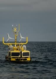
Offshore wind is scaling fast, and reliable environmental data has become the foundation of every viable project. Today, Venterra Group has launched the world’s first UK-designed and manufactured global fleet of dual LiDAR buoys, unlocking better resource assessment, safer deployment, and wider operational access. A total investment of USD 13 million reflects both confidence and ambition. The new Venterra V-LiDAR fleet offers high frequency analytics and future-proof export value for British offshore innovation.
The buoys are engineered by Osbit and developed by Partrac at a brand-new facility in Port of Blyth. These systems gather critical wind behavior insights to strengthen business models, financing decisions and power output predictions across Europe, Asia and North America. For the booming offshore wind sector, this is a leap toward efficiency with lower risk.
A Global Breakthrough in Offshore Wind Data Performance
The Venterra V-LiDAR is more than a marine instrument. It is a real-time decision support system. Equipped with dual LiDAR technology, the buoys offer accuracy equal to traditional meteorological masts. They are also faster to deploy and cost far less to install and maintain.
These buoys integrate marine electronics, robust communications, and cloud-linked analytics to improve uptime while capturing long-term wind profiles. Developers are pushing projects into harsher waters where conventional data platforms would fail. Here, increased operational windows and lighter deployment methods help reduce vessel time at sea and enhance safety.
The timing aligns with strong growth in floating wind. The ability to collect data farther offshore reduces uncertainty in new markets such as Japan, South Korea, and the US West Coast. Every percentage gain in power curve understanding translates into millions saved in financing and design.
What Makes the V-LiDAR Buoys Different
Their design focuses on four performance priorities:
- Dual LiDAR configuration
Two independent systems validate each data point in real time, improving accuracy. - Modular British engineering
Manufactured in the UK to optimize maintainability and supply chain independence. - Operational flexibility
Deployment in deeper or more turbulent environments with minimal downtime. - Advanced analytics platform
High-frequency data streaming reduces modeling uncertainty for developers and investors.
By reducing the need for fixed met masts, operators also avoid complex seabed permitting and construction delays. This accelerates timelines for portfolio-scale planning and power purchase agreement negotiations.
Technology Overview at a Glance
Key Specifications and Strategic Value
| Feature | Impact for Offshore Wind | Value Delivered |
|---|---|---|
| Dual LiDAR sensors | Collects two precise datasets simultaneously | Better accuracy, lower financing risk |
| High frequency analytics | Continuous monitoring of wind profiles | Improved yield modeling and O&M efficiency |
| Light and modular design | Faster deployment in more weather windows | Reduced vessel costs and HSE exposure |
| UK manufacturing | Strengthens local content compliance | Drives export growth and job creation |
| Global fleet availability | Ready for Tier-1 developers across regions | Shorter project development cycles |
Venterra expects global demand to rise as offshore wind expands from 75 GW today to more than 250 GW by 2030.
Why This Matters for the UK and the Global Supply Chain
The V-LiDAR project supports a growing British industrial ecosystem. With the Port of Blyth emerging as a strategic innovation hub, the UK reinforces its competitive edge in offshore wind project services. This aligns with national goals to boost exports and deliver climate-aligned economic growth.
Creating a homegrown capability also helps developers comply with local-content requirements in key markets. Governments increasingly expect clean energy infrastructure to stimulate domestic employment. The UK now has a solution built to travel.
The fleet supports existing clients and is positioned to bring Tier-1 developer partnerships to new regions. With the US, Taiwan and Europe preparing major leasing rounds, demand for robust metocean intelligence will intensify.
Trending FAQ
How do floating LiDAR buoys compare with traditional meteorological masts?
They provide equivalent data accuracy with lower installation cost and zero seabed infrastructure, making them ideal for deeper waters.
Why is dual LiDAR so important?
Two simultaneous datasets validate each measurement, reducing uncertainty for investors and turbine designers.
Will these buoys support floating offshore wind?
Yes. They are optimized for harsher offshore environments expected in floating wind growth markets.
What kind of data do they collect?
Wind speed, direction, shear profile, wave statistics and atmospheric stability indices at multiple heights.
Who are the main customers?
Top-tier offshore wind developers in Europe, North America and Asia seeking precise long-term resource assessment.
What is the environmental impact of deployment?
Minimal. No seabed foundation is required, and smaller vessels reduce marine disturbance.
Final Outlook: A Force Multiplier for the Offshore Wind Future
Offshore wind’s next phase demands smarter tools. The Venterra V-LiDAR fleet offers actionable, accurate and continuously available data that can cut project risk while maximizing return on investment. As the pressure grows to deliver clean energy faster and more affordably, technologies like this will be the difference between theoretical capacity and real generation.
Venterra Group’s launch signals a confident shift for UK offshore manufacturing. With stronger data capabilities now on the water, project developers worldwide are better equipped to scale up offshore wind in places once considered too costly or uncertain.
The global energy transition requires innovation at every point in the pipeline. Here, progress begins with precision.
